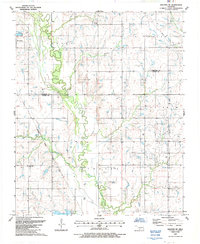
1987 Map of Walters NE
USGS Topo · Published 1987About this map
East Cache Creek meanders through the heart of this Southern Oklahoma landscape, defining the topography of the Crosby, Hulen, and Strauss regions. The settlement of Geronimo sits in the northwest, while rural life is anchored by landmarks like New Salem Ch and Allendale Cem. The presence of numerous Oil Wells and Oil Well sites across the eastern half of the map illustrates the local dependence on the petroleum industry during the late twentieth century. In the south, Sultan Park and the edges of Dave Boyer Lake provide recreational contrast to the industrial footprint of the Gravel Pits found near the Comanche and Cotton county line. This survey captures a specific moment in the evolution of the regional road and energy network, including the path of the Oklahoma Snake Kansas and Texas route.
Find a feature on this map
20 named features on this map. Tap any name to fly to it.
Don’t see what you’re looking for? This feature index may not catch every label — zoom into the map to look around manually.
Map Details
Editions of this 1987 Walters NE Map
This is the sole edition of this map. No revisions or reprints were ever made.
Other maps of this area

1946 · Lawton
USGS Topo · 1:62,500

1949 · Nellie
USGS Topo · 1:62,500

1955 · Lawton
USGS Topo · 1:250,000

1956 · Ninemile Creek
USGS Topo · 1:24,000

1956 · Lawton
USGS Topo · 1:24,000

1956 · Letitia
USGS Topo · 1:24,000

1956 · Lawton
USGS Topo · 1:62,500

1956 · Nellie
USGS Topo · 1:62,500

1962 · Walters
USGS Topo · 1:62,500

1962 · Temple
USGS Topo · 1:62,500