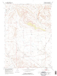
1952 Map of Waltman NW
USGS Topo · Published 1995About this map
Ralston Flats dominates the center of this Wyoming interior, a landscape defined by seasonal drainages and isolated livestock operations during the early 1950s. The mapping documents a network of family-held territories including McClellan Ranch in the north and Rochelle Ranch positioned near a bend in the North Branch Dean Springs Draw. These outposts represent the high-plains ranching economy that persisted in the decades following initial settlement, dependent on sparse water sources like Jackpot Reservoir and Poison Creek.
Find a feature on this map
15 named features on this map. Tap any name to fly to it.
Don’t see what you’re looking for? This feature index may not catch every label — zoom into the map to look around manually.
Map Details
Editions of this 1952 Waltman NW Map
2 editions found
Other maps of this area

1952 · Deadman Butte
USGS Topo · 1:24,000

1952 · Arminto
USGS Topo · 1:24,000

1952 · Waltman NW
USGS Topo · 1:24,000

1952 · Waltman
USGS Topo · 1:24,000

1952 · Hiland
USGS Topo · 1:24,000

1952 · Badwater SE
USGS Topo · 1:24,000

1955 · Arminto
USGS Topo · 1:250,000

1958 · Arminto
USGS Topo · 1:250,000

1962 · Arminto
USGS Topo · 1:250,000
1968 · Notches Dome
USGS Topo · 1:24,000