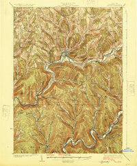
1925 Map of Walton
USGS Topo · Published 1925About this map
Walton stands as the central hub of this Catskill region, where the New York Ontario and Western RR tracks follow the winding course of the West Branch Delaware River. The 1920s landscape is defined by its deep narrow valleys and numerous small rural districts, each centered around a local schoolhouse such as Knickerbocker School, Carcass Brook School, or Shinhopple School. This era precedes the construction of the Pepacton Reservoir, showing the East Branch Delaware River flowing freely through riverside hamlets like Downsville, Shinhopple, and Corbett. The mapping of dozens of small schools and family-named hollows, including Chambers Hollow School and Launt Hollow School, provides a meticulous view of the educational and social organization of Delaware County prior to mid-century rural consolidation.
Find a feature on this map
77 named features on this map. Tap any name to fly to it.
Don’t see what you’re looking for? This feature index may not catch every label — zoom into the map to look around manually.
Map Details
Editions of this 1925 Walton Map
5 editions found

Other maps of this area

1909 · Delhi
USGS Topo · 1:62,500

1911 · Delhi
USGS Topo · 1:62,500

1915 · Oneonta
USGS Topo · 1:62,500

1915 · Unadilla
USGS Topo · 1:62,500

1918 · Unadilla
USGS Topo · 1:62,500

1918 · Oneonta
USGS Topo · 1:62,500

1920 · Long Eddy
USGS Topo · 1:62,500

1921 · Long Eddy
USGS Topo · 1:48,000

1921 · Livingston Manor
USGS Topo · 1:62,500

1922 · Andes
USGS Topo · 1:62,500