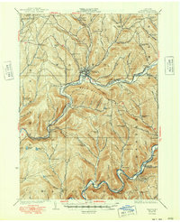
1925 Map of Walton
USGS Topo · Published 1948About this map
Walton serves as the central hub of this Catskill region landscape, where the New York Ontario and Western RR follows the winding course of the West Branch Delaware River. The map illustrates a rural society organized around a dense network of district schools, such as Carcass Brook School, Fuller Hollow School, and Seely School, each serving localized hollows and ridges. Transportation is defined by the river valleys, with the Liberty Highway cutting through the southern portion near Harvard School. Higher elevations like Bear Spring Mountain and South Mtn separate the drainage basins, while smaller settlements like Beerston, Rock Rift, and Shinhopple anchor the valley communities. The presence of numerous named brooks and ponds, including Beaver Meadow Pond and Russ Gray Pond, highlights the water-driven geography that dictated the placement of early roads and rail sidings like Russell Siding.
Find a feature on this map
120 named features on this map. Tap any name to fly to it.
Don’t see what you’re looking for? This feature index may not catch every label — zoom into the map to look around manually.
Map Details
Editions of this 1925 Walton Map
5 editions found

Other maps of this area

1909 · Delhi
USGS Topo · 1:62,500

1911 · Delhi
USGS Topo · 1:62,500

1915 · Oneonta
USGS Topo · 1:62,500

1915 · Unadilla
USGS Topo · 1:62,500

1918 · Unadilla
USGS Topo · 1:62,500

1918 · Oneonta
USGS Topo · 1:62,500

1920 · Long Eddy
USGS Topo · 1:62,500

1921 · Long Eddy
USGS Topo · 1:48,000

1921 · Livingston Manor
USGS Topo · 1:62,500

1922 · Andes
USGS Topo · 1:62,500