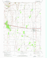
1972 Map of Wanatah
USGS Topo · Published 1974About this map
Wanatah sits at a major rail junction in rural LaPorte County, where the Penn Central, Grand Trunk and Western, and Norfolk and Western railroads converge. This 1970s landscape is defined by its extensive drainage network, including Bigelow Mill Ditch and Slocum Ditch, which support the surrounding agricultural fields of Washington and Clinton townships. The map records localized landmarks such as Sacred Heart Ch and the Luther Cem, alongside civil infrastructure like the County Airport and the Washington Sch. South of the main settlement, South Wanatah serves as another node along the rail lines, while the small community of Haskell remains visible in the northern section of the sheet. The grid of numbered roads, such as Division Road and 0 Road, illustrates the late 20th-century transportation layout of this Northwest Indiana crossroads.
Find a feature on this map
41 named features on this map. Tap any name to fly to it.
Don’t see what you’re looking for? This feature index may not catch every label — zoom into the map to look around manually.
Map Details
Editions of this 1972 Wanatah Map
This is the sole edition of this map. No revisions or reprints were ever made.
Other maps of this area

1934 · Porter
USGS Topo · 1:48,000

1940 · Porter
USGS Topo · 1:62,500

1953 · Wanatah
USGS Topo · 1:24,000

1953 · Westville
USGS Topo · 1:24,000

1953 · Valparaiso
USGS Topo · 1:24,000

1953 · Chesterton
USGS Topo · 1:24,000

1953 · Kouts
USGS Topo · 1:24,000

1953 · Chicago
USGS Topo · 1:250,000

1957 · Chicago
USGS Topo · 1:250,000

1958 · La Crosse
USGS Topo · 1:24,000