1919 Map of Wando
USGS Topo · Published 1919About this map
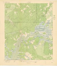
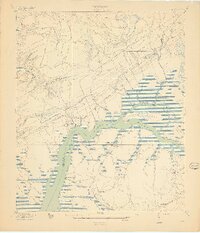
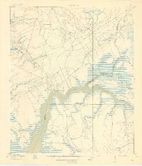
The Wando River serves as the central artery for this coastal landscape, where the tidal marsh and wooded lowlands of Berkeley and Charleston counties met in the years following World War I. Small riverside settlements like Wando and Cainhoy are documented at a time when water transport and early overland routes defined local movement. Several rural institutions are mapped, including St Matthews Church, Robertson Church, and St Pauls Church, alongside educational sites such as Phillips School and Christ Church Academy. The map illustrates the era's reliance on river access points, specifically marking Lachicotte Landing and Martins Point Landing, which likely facilitated the transport of timber and agricultural goods. A network of named roads, such as Lumber Road and Ferry Road, connects the inland woods to the marshy tributaries like Guerin Creek and Clement Creek.
Find a feature on this map
36 named features on this map. Tap any name to fly to it.
Don’t see what you’re looking for? This feature index may not catch every label — zoom into the map to look around manually.
Map Details
Editions of this 1919 Wando Map
5 editions found

Other maps of this area

1919 · Capers Island
USGS Topo · 1:21,120

1919 · Wando
USGS Topo · 1:21,120

1919 · Cordesville
USGS Topo · 1:48,000

1919 · Melgrove
USGS Topo · 1:21,120

1919 · Charleston
USGS Topo · 1:21,120

1919 · Fort Moultrie
USGS Topo · 1:21,120

1919 · Sewee Bay
USGS Topo · 1:21,120

1940 · Melgrove
USGS Topo · 1:24,000

1943 · Capers Island
USGS Topo · 1:24,000

1943 · Fort Moultrie
USGS Topo · 1:24,000