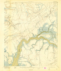
1919 Map of Wando
USGS Topo · Published 1942About this map
The Wando River dominates this coastal landscape, serving as the primary thoroughfare for the settlements of Wando and Cainhoy during the early twentieth century. This survey, conducted in cooperation with the War Department, reveals a region defined by its tidal waterways and scattered rural centers of community life. Several local landmarks suggest a well-established social fabric, including St Matthews Church, Robertson Church, and the Christ Church Academy. The map documents the critical intersection of water and land travel, marking points of transit such as Lachicotte Landing, Martins Point Landing, and the Guerin Bridge.
Find a feature on this map
31 named features on this map. Tap any name to fly to it.
Don’t see what you’re looking for? This feature index may not catch every label — zoom into the map to look around manually.
Map Details
Editions of this 1919 Wando Map
5 editions found
Other maps of this area

1919 · Capers Island
USGS Topo · 1:21,120

1919 · Wando
USGS Topo · 1:21,120

1919 · Cordesville
USGS Topo · 1:48,000

1919 · Melgrove
USGS Topo · 1:21,120

1919 · Charleston
USGS Topo · 1:21,120

1919 · Fort Moultrie
USGS Topo · 1:21,120

1919 · Sewee Bay
USGS Topo · 1:21,120

1940 · Melgrove
USGS Topo · 1:24,000

1943 · Capers Island
USGS Topo · 1:24,000

1943 · Fort Moultrie
USGS Topo · 1:24,000