1972 Map of Wann
USGS Topo · Published 1974About this map
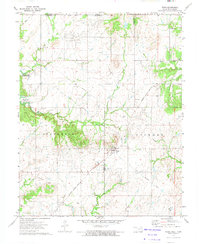
Wann sits at the heart of this landscape along the border of Washington and Nowata counties. The early 1970s marked a period of significant transformation for the area as the Copan Lake project began altering the western terrain. The survey captures a network of former industrial and transport routes, including the Missouri - Kansas - Texas Railroad Grade and an Old Railroad Grade that once connected these rural settlements. Local life is centered around several religious sites such as the Oakdale Ch, Oakdale Free Holiness Ch, and the Church of the Firstborn. The geography is further defined by numerous extraction sites, with Oil Fields, Oil Wells, and several Drill Holes scattered across the land, signifying the importance of the petroleum industry to the regional economy alongside the drainage of Cotton Creek and California Creek.
Find a feature on this map
28 named features on this map. Tap any name to fly to it.
Don’t see what you’re looking for? This feature index may not catch every label — zoom into the map to look around manually.
Map Details
Editions of this 1972 Wann Map
This is the sole edition of this map. No revisions or reprints were ever made.
Other maps of this area

1886 · Independence
USGS Topo · 1:125,000

1894 · Independence
USGS Topo · 1:125,000

1901 · Nowata
USGS Topo · 1:125,000

1905 · Independence
USGS Topo · 1:125,000

1914 · Nowata
USGS Topo · 1:125,000

1947 · Joplin
USGS Topo · 1:250,000

1949 · Joplin
USGS Topo · 1:250,000

1954 · Tulsa
USGS Topo · 1:250,000

1954 · Joplin
USGS Topo · 1:250,000

1958 · Joplin
USGS Topo · 1:250,000