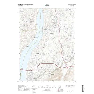
2019 Map of Wappingers Falls
USGS Topo · Published 2019About this map
The Hudson River carves a deep path through this landscape, separating the communities of Beacon and Fishkill from the western shores of Marlboro and Roseton. This contemporary survey reveals a densely developed river corridor where industrial history and modern infrastructure meet, anchored by the Newburgh-Beacon Bridge. Settlement patterns follow the rugged topography of the Beacon Hills and Verplanck Ridge, while historical burial grounds like the First Reformed Protestant Dutch Cem and Saint Joachims Cem reflect the area's long-standing genealogical roots. The waterway itself remains the central character, defined by landmarks such as Danskammer Point and the confluence where Wappinger Creek flows past New Hamburg. Transportation networks are prominent, from the historic Albany Post Rd to the more recent Merritt Blvd corridor, illustrating the continued evolution of this Hudson Valley hub.
Find a feature on this map
51 named features on this map. Tap any name to fly to it.
Don’t see what you’re looking for? This feature index may not catch every label — zoom into the map to look around manually.
Map Details
Editions of this 2019 Wappingers Falls Map
This is the sole edition of this map. No revisions or reprints were ever made.
Other maps of this area

1892 · West Point
USGS Topo · 1:62,500

1893 · Poughkeepsie
USGS Topo · 1:62,500

1894 · West Point
USGS Topo · 1:62,500

1894 · Poughkeepsie
USGS Topo · 1:62,500

1899 · West Point
USGS Topo · 1:62,500

1901 · West Point
USGS Topo · 1:62,500

1902 · Schunemunk
USGS Topo · 1:62,500

1903 · Poughkeepsie
USGS Topo · 1:62,500

1903 · Newburg
USGS Topo · 1:62,500

1930 · Schunemunk
USGS Topo · 1:48,000