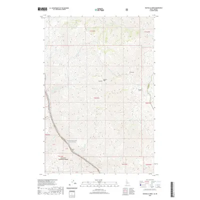
2020 Map of Wapshilla Creek
USGS Topo · Published 2020About this map
The Snake Wild and Scenic River and Salmon River dominate this borderland where Idaho meets Oregon. This steep, river-carved landscape is defined by massive elevation changes between the water level and the high plateaus of Craig Mtn. Along the rivers, small named bars and rapids like Geneva Bar, Wapshilla Rapids, and Frenchy Rapids mark the difficult passage through the canyon. The interior upland is largely uninhabited, characterized by the prominent Wapshilla Ridge and numerous seasonal drainage systems such as Birch Cr and Cottonwood Cr. Human infrastructure is sparse, limited to the isolated Wapshilla Airport and the remote reaches of the Wallowa National Forest, emphasizing the area's role as a protected wilderness corridor at the start of the twenty-first century.
Find a feature on this map
48 named features on this map. Tap any name to fly to it.
Don’t see what you’re looking for? This feature index may not catch every label — zoom into the map to look around manually.
Map Details
Editions of this 2020 Wapshilla Creek Map
This is the sole edition of this map. No revisions or reprints were ever made.
Other maps of this area

1946 · Limekiln Rapids
USGS Topo · 1:62,500

1955 · Pullman
USGS Topo · 1:250,000

1955 · Grangeville
USGS Topo · 1:250,000

1958 · Pullman
USGS Topo · 1:250,000

1959 · Grangeville
USGS Topo · 1:250,000

1963 · Cactus Mtn
USGS Topo · 1:24,000

1963 · Deadhorse Ridge
USGS Topo · 1:24,000

1963 · Jim Creek Butte
USGS Topo · 1:24,000

1963 · Rattlesnake Ridge
USGS Topo · 1:24,000

1963 · Wapshilla Creek
USGS Topo · 1:24,000