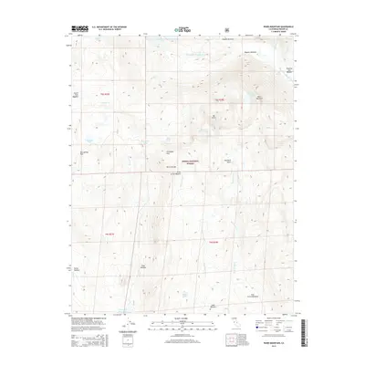
2015 Map of Ward Mountain
USGS Topo · Published 2015About this map
Sierra National Forest dominates this high-altitude landscape in the Sierra Nevada, where the drainage systems of the S Fork San Joaquin River and various creeks define the terrain. The map captures a complex network of alpine meadows and water bodies, including the expansive Florence Lake in the north and Courtright Reservoir at the southern edge. The distribution of high meadows such as Blayney Meadows, Post Corral Meadows, and Dusy Meadow suggests a seasonal rhythm of grazing and travel through this wilderness. Prominent peaks and passes, notably Ward Mountain and Hot Springs Pass, anchor the topography, while features like Mount Shinn Lake and Hobler Lake indicate a glaciated environment rich in high-country water resources. This detailed record tracks the preservation of these lands within the national forest system during the early 21st century.
Find a feature on this map
37 named features on this map. Tap any name to fly to it.
Don’t see what you’re looking for? This feature index may not catch every label — zoom into the map to look around manually.
Map Details
Editions of this 2015 Ward Mountain Map
This is the sole edition of this map. No revisions or reprints were ever made.
Other maps of this area

1904 · Kaiser
USGS Topo · 1:125,000

1912 · Mt. Goddard
USGS Topo · 1:125,000

1947 · Mariposa
USGS Topo · 1:250,000

1948 · Mariposa
USGS Topo · 1:250,000

1953 · Mt Abbot
USGS Topo · 1:62,500

1953 · Huntington Lake
USGS Topo · 1:62,500

1953 · Blackcap Mtn
USGS Topo · 1:62,500

1953 · Kaiser Peak
USGS Topo · 1:62,500

1957 · Mariposa
USGS Topo · 1:250,000
1962 · Blackcap Mtn
USGS Topo · 1:62,500