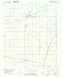
1978 Map of Wardell
USGS Topo · Published 1979About this map
The Little River meanders through this agricultural landscape in Pemiscot County, serving as the central geographic anchor for several small Missouri Bootheel communities in the late 1970s. The town of Wardell stands at the heart of the region, flanked by North Wardell and the settlement of Homestown. Further south, the ST Louis-San Francisco railroad line cuts through the terrain, connecting the town of Pascola with smaller stops like Netherlands and Swift.
Find a feature on this map
25 named features on this map. Tap any name to fly to it.
Don’t see what you’re looking for? This feature index may not catch every label — zoom into the map to look around manually.
Map Details
Editions of this 1978 Wardell Map
This is the sole edition of this map. No revisions or reprints were ever made.
Other maps of this area

1939 · Portageville
USGS Topo · 1:62,500

1939 · Caruthersville
USGS Topo · 1:62,500

1940 · Pascola
USGS Topo · 1:62,500

1940 · Hayti
USGS Topo · 1:62,500

1951 · Caruthersville
USGS Topo · 1:62,500

1955 · Pascola
USGS Topo · 1:62,500

1955 · Hayti
USGS Topo · 1:62,500

1955 · Portageville
USGS Topo · 1:62,500

1956 · Dyersburg
USGS Topo · 1:250,000

1957 · Caruthersville
USGS Topo · 1:62,500