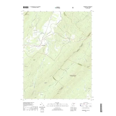
2019 Map of Wardensville
USGS Topo · Published 2019About this map
Wardensville serves as the central hub of this terrain where the Cacapon River meets Waites Run and Moores Run. The landscape is defined by the steep ridges of the George Washington National Forest, including Great North Mountain and Paddy Mtn. For genealogists and local historians, several small burial sites are documented across the valley floor, including Clagett Cem, the Alum- Bank Cem, and Wilson Cem. The area’s water resources are a prominent feature, with numerous named springs such as Boiling Spring, Pee Wee Spring, and the Wardensville Spring. A network of older mountain routes like the Old Mailpath and Furnace Rd suggests the historical movement patterns of Hardy County before modern infrastructure. The eastern edge of the map follows the winding interstate boundary between West Virginia and Virginia, cutting through high elevations like Bonnet Hill.
Find a feature on this map
72 named features on this map. Tap any name to fly to it.
Don’t see what you’re looking for? This feature index may not catch every label — zoom into the map to look around manually.
Map Details
Editions of this 2019 Wardensville Map
This is the sole edition of this map. No revisions or reprints were ever made.
Other maps of this area

1891 · Romney
USGS Topo · 1:125,000

1892 · Woodstock
USGS Topo · 1:125,000

1893 · Luray
USGS Topo · 1:125,000

1894 · Winchester
USGS Topo · 1:125,000

1905 · Luray
USGS Topo · 1:125,000

1922 · Wardensville
USGS Topo · 1:62,500

1923 · Middletown
USGS Topo · 1:62,500

1923 · Edinburg
USGS Topo · 1:62,500

1924 · Wardensville
USGS Topo · 1:62,500

1937 · Middletown
USGS Topo · 1:48,000