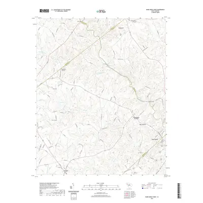
2020 Map of Ware Shoals West
USGS Topo · Published 2020About this map
Rutledge Shoals and Maddox Shoals drop along the Saluda River, defining the riverine landscape where the borders of Greenville, Anderson, Laurens, Abbeville, and Greenwood counties converge. This 2020 survey reveals a community anchored by rural centers like Princeton and Donalds, with long-standing religious institutions such as Princeton Baptist Church and Broadmouth Baptist Church serving as local landmarks. The area's transport and drainage network is remarkably detailed, tracing the winding paths of Broad Mouth Creek and Turkey Cr alongside a dense grid of family-named roads like Cleveland Rd and Taylor Rd. From the residential pocket of Blue Heaven to the industrial and transit points at MacArthurs Junction and Ware Shoals, the map documents a region where agricultural roots and river-driven geography remain central to the local identity.
Find a feature on this map
105 named features on this map. Tap any name to fly to it.
Don’t see what you’re looking for? This feature index may not catch every label — zoom into the map to look around manually.
Map Details
Editions of this 2020 Ware Shoals West Map
This is the sole edition of this map. No revisions or reprints were ever made.
Other maps of this area

1892 · Abbeville
USGS Topo · 1:125,000

1954 · Greenville
USGS Topo · 1:250,000

1957 · Fountain Inn
USGS Topo · 1:62,500

1957 · Williamston
USGS Topo · 1:62,500

1958 · Greenville
USGS Topo · 1:250,000
1970 · Honea Path
USGS Topo · 1:24,000
1971 · Cokesbury
USGS Topo · 1:24,000
1971 · Due West
USGS Topo · 1:24,000
1971 · Ware Shoals East
USGS Topo · 1:24,000
1971 · Shoals Junction
USGS Topo · 1:24,000