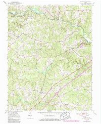
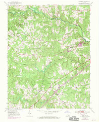
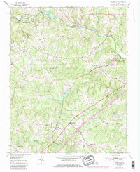
1951 Map of Warfield
USGS Topo · Published 1986About this map
The Nottoway River forms the northern boundary of this Brunswick and Dinwiddie County landscape, separating agricultural lands from the Fort Pickett Military Reservation. The mid-century transportation network is anchored by the Seaboard Coast Line and the Davis Highway, which connect the small settlements of Warfield and Rawlings. This survey, updated with 1980s data, captures a rural community defined by its local institutions, including the Warfield School, Antioch Church, and Lebanon Church. The terrain is intricately dissected by numerous watercourses such as Waqua Creek and Beaver Pond Creek, illustrating the natural drainage patterns that shaped early Virginia settlement and land use. Genealogists will find interest in the proximity of family-centered landmarks like Sturgeonville and several rural schools such as the Gilliam School.
Find a feature on this map
31 named features on this map. Tap any name to fly to it.
Don’t see what you’re looking for? This feature index may not catch every label — zoom into the map to look around manually.
Map Details
Editions of this 1951 Warfield Map
4 editions found

Other maps of this area

1897 · Amelia
USGS Topo · 1:125,000

1918 · Lawrenceville
USGS Topo · 1:62,500

1919 · Mc Kenney
USGS Topo · 1:48,000

1920 · Lawrenceville
USGS Topo · 1:48,000

1921 · Mc Kenney
USGS Topo · 1:62,500

1921 · Lawrenceville
USGS Topo · 1:62,500

1942 · Lawrenceville
USGS Topo · 1:62,500

1943 · Mc Kenney
USGS Topo · 1:62,500

1943 · De Witt
USGS Topo · 1:24,000

1943 · Richmond
USGS Topo · 1:250,000