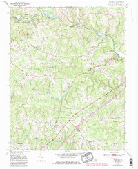
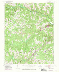
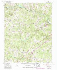
1951 Map of Warfield
USGS Topo · Published 1986About this map
The Nottoway River meanders along the northern boundary of this Brunswick and Dinwiddie County landscape, marking the transition between the Fort Pickett Military Reservation and the agricultural settlements to the south. The rural character of the mid-20th century is centered on the Seaboard Coast Line railroad, which links the communities of Rawlings, Warfield, and Kress. These rail-side hubs served as local focal points for transportation and commerce before the expansion of the Jefferson Davis Highway significantly altered local transit patterns.
Find a feature on this map
34 named features on this map. Tap any name to fly to it.
Don’t see what you’re looking for? This feature index may not catch every label — zoom into the map to look around manually.
Map Details
Editions of this 1951 Warfield Map
4 editions found

Other maps of this area

1897 · Amelia
USGS Topo · 1:125,000

1918 · Lawrenceville
USGS Topo · 1:62,500

1919 · Mc Kenney
USGS Topo · 1:48,000

1920 · Lawrenceville
USGS Topo · 1:48,000

1921 · Mc Kenney
USGS Topo · 1:62,500

1921 · Lawrenceville
USGS Topo · 1:62,500

1942 · Lawrenceville
USGS Topo · 1:62,500

1943 · Mc Kenney
USGS Topo · 1:62,500

1943 · De Witt
USGS Topo · 1:24,000

1943 · Richmond
USGS Topo · 1:250,000