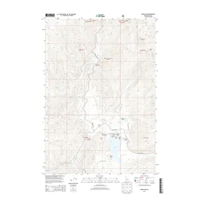
2013 Map of Warm Lake
USGS Topo · Published 2013About this map
Warm Lake and the surrounding reaches of the Boise National Forest define this high-elevation landscape in Valley County. The S Fork Salmon River cuts a deep path through the center of the sheet, joined by numerous tributaries including Dollar Cr and Knox Cr. This 2013 survey provides significant detail for researchers of the area's recreational development and local landmarks, noting several managed sites such as the Shoreline Campground and the Warm Lake Lodge Campground. A notable site of local history is recorded at Klines Grave, situated near the junction of Warm Lake Rd and the river valley. The terrain is marked by prominent summits like Thunderbolt Mtn and Cline Mtn, while unique water features such as Aunt Mellis Spring and the Billy Rice Public Swimming Area reflect the long-standing importance of this basin for regional visitors.
Find a feature on this map
79 named features on this map. Tap any name to fly to it.
Don’t see what you’re looking for? This feature index may not catch every label — zoom into the map to look around manually.
Map Details
Editions of this 2013 Warm Lake Map
This is the sole edition of this map. No revisions or reprints were ever made.
Other maps of this area

1954 · Gold Fork
USGS Topo · 1:62,500

1954 · Warm Lake
USGS Topo · 1:62,500

1957 · Challis
USGS Topo · 1:250,000

1960 · Challis
USGS Topo · 1:250,000

1963 · Challis
USGS Topo · 1:250,000

1973 · Blackmare
USGS Topo · 1:24,000

1973 · White Rock Peak
USGS Topo · 1:24,000
1973 · Log Mountain
USGS Topo · 1:24,000

1982 · Pistol Creek
USGS Topo · 1:100,000
1988 · Gold Fork Rock
USGS Topo · 1:24,000