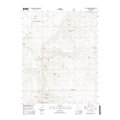
2014 Map of Warm Springs Canyon
USGS Topo · Published 2014About this map
Kaibab National Forest dominates this high-plateau landscape in northern Arizona, where deep drainages like Snake Gulch and Moquitch Canyon carve through the limestone and sandstone terrain. The map records a series of critical water sources essential for life in this arid environment, ranging from Oak Spring and Moquitch Spring to numerous catchment tanks such as Beef Tank and Jacob Canyon Tank. Settlement remains sparse, represented by the locations of Ryan and Mangum Springs, while the transit corridor of US Hwy 89 Alt Scenic skirts the northeastern corner.
Find a feature on this map
49 named features on this map. Tap any name to fly to it.
Don’t see what you’re looking for? This feature index may not catch every label — zoom into the map to look around manually.
Map Details
Editions of this 2014 Warm Springs Canyon Map
This is the sole edition of this map. No revisions or reprints were ever made.
Other maps of this area

1886 · Kaibab
USGS Topo · 1:250,000

1936 · Jacobs Lake
USGS Topo · 1:48,000

1940 · Jacob Lake
USGS Topo · 1:62,500

1953 · Jacobs Lake
USGS Topo · 1:62,500

1953 · Grand Canyon
USGS Topo · 1:250,000

1957 · Grand Canyon
USGS Topo · 1:250,000

1957 · Shinarump SE
USGS Topo · 1:24,000
1957 · House Rock Spring SW
USGS Topo · 1:24,000

1957 · Shinarump SW
USGS Topo · 1:24,000
1957 · House Rock Spring
USGS Topo · 1:62,500