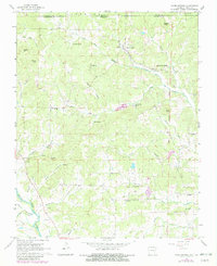
1967 Map of Warm Springs
USGS Topo · Published 1982About this map
The Eleven Point River flows through the southwestern corner of this Ozark foothills landscape, anchoring a region of rugged drainage and small agricultural clearings. At the center of the survey is Warm Springs, where the terrain transitions from the high ground of Phillips Knob and Bellah Hills toward the southern valleys. The map documents a dense network of local family history markers, including the Whittenberg Cem and Spikes Cem, alongside rural social hubs like Macedonia Ch and Antioch Ch. Following the Fifth Principal Meridian, the survey reveals how early land divisions shaped the placement of farmsteads and rural roads. Dozens of named water sources like Whittenberg Spring and Catto Spring highlight the critical importance of reliable water for the scattered residents of Ingram and the surrounding hills during the late 1960s.
Find a feature on this map
49 named features on this map. Tap any name to fly to it.
Don’t see what you’re looking for? This feature index may not catch every label — zoom into the map to look around manually.
Map Details
Editions of this 1967 Warm Springs Map
2 editions found
Other maps of this area

1935 · Reyno
USGS Topo · 1:62,500

1939 · Doniphan
USGS Topo · 1:62,500

1941 · Gatewood
USGS Topo · 1:62,500

1945 · Doniphan
USGS Topo · 1:62,500

1945 · Gatewood
USGS Topo · 1:62,500

1957 · Poplar Bluff
USGS Topo · 1:250,000

1959 · Poplar Bluff
USGS Topo · 1:250,000

1960 · Poplar Bluff
USGS Topo · 1:250,000

1965 · Gatewood
USGS Topo · 1:24,000

1966 · Ravenden Springs
USGS Topo · 1:24,000