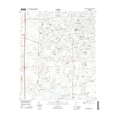
2014 Map of Warner Robins SW
USGS Topo · Published 2014About this map
Centerville and the southwestern outskirts of Warner Robins define this Houston County landscape, illustrating the rapid suburban expansion of the early 21st century. The map reveals a dense network of residential subdivisions like Shirley Hills Estates, Quail Meadow, and Peachtree Estates, which have replaced much of the former agricultural land. Significant local aviation infrastructure is prominent, including Smith Field Airport, Peachtree Landings Airport, and Warner Robins Air Park, reflecting the area's ties to the nearby military installation.
Find a feature on this map
82 named features on this map. Tap any name to fly to it.
Don’t see what you’re looking for? This feature index may not catch every label — zoom into the map to look around manually.
Map Details
Editions of this 2014 Warner Robins SW Map
This is the sole edition of this map. No revisions or reprints were ever made.
Other maps of this area

1956 · Fort Valley
USGS Topo · 1:62,500

1956 · Perry
USGS Topo · 1:62,500

1956 · Warner Robins
USGS Topo · 1:62,500

1957 · Macon
USGS Topo · 1:250,000

1958 · Macon
USGS Topo · 1:250,000

1964 · Macon
USGS Topo · 1:250,000

1972 · Perry West
USGS Topo · 1:24,000

1973 · Hayneville
USGS Topo · 1:24,000

1973 · Warner Robins NE
USGS Topo · 1:24,000
1973 · Warner Robins SE
USGS Topo · 1:24,000