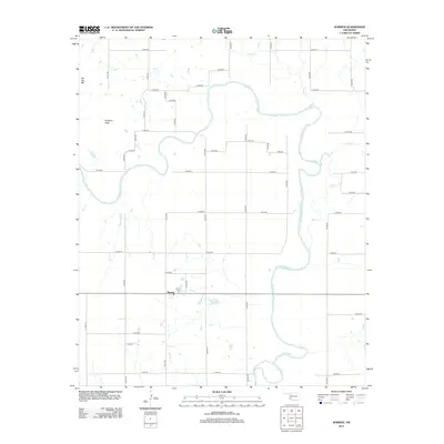
2012 Map of Warren
USGS Topo · Published 2012About this map
The Warren community serves as the primary landmark in this section of southwestern Oklahoma, located just south of a large bend in the N Fork Red River. The landscape is defined by the river's winding path and its tributaries, including Elk Cr and Tepee Cr, which cut through the agricultural grid. To the northwest, the terrain rises toward Flat Top Mtn and Soldiers Peak, providing a stark contrast to the surrounding lowlands. This survey illustrates the rural nature of Jackson County in the early 21st century, where the local economy and settlement patterns are clearly tied to the river's drainage basin and an extensive network of section-line roads like E 1500 Rd. For those researching family history in the area, the Warren Cem is documented near the town center.
Find a feature on this map
35 named features on this map. Tap any name to fly to it.
Don’t see what you’re looking for? This feature index may not catch every label — zoom into the map to look around manually.
Map Details
Editions of this 2012 Warren Map
This is the sole edition of this map. No revisions or reprints were ever made.
Other maps of this area

1955 · Lawton
USGS Topo · 1:250,000

1963 · Babbs
USGS Topo · 1:24,000

1964 · Altus
USGS Topo · 1:24,000

1964 · Lone Wolf
USGS Topo · 1:24,000

1964 · Warren
USGS Topo · 1:24,000

1964 · Headrick
USGS Topo · 1:24,000
1964 · Roosevelt
USGS Topo · 1:24,000

1964 · Long Mountain
USGS Topo · 1:24,000

1971 · Blair
USGS Topo · 1:24,000

1971 · Lake Altus
USGS Topo · 1:24,000