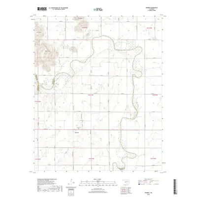
2018 Map of Warren
USGS Topo · Published 2018About this map
Warren anchors the southern portion of this landscape, situated just south of the Warren Cem. This rural Oklahoma territory is defined by the winding course of the North Fork Red River, which serves as a natural boundary between Jackson, Kiowa, and Greer Counties. To the north, the terrain shifts from river bottomlands to prominent elevations including Soldiers Peak, Tepee Mtn, and Flat Top Mtn. The historic Western Trl cuts north-south through the center of the survey, tracing an old cattle driving route across the plains. Smaller watercourses like Tepee Cr and Elk Cr feed into the river system, while a grid of local roads, such as Warren Rd and Navajoe Rd, connects the scattered farmsteads and rural homesteads characteristic of the region.
Find a feature on this map
51 named features on this map. Tap any name to fly to it.
Don’t see what you’re looking for? This feature index may not catch every label — zoom into the map to look around manually.
Map Details
Editions of this 2018 Warren Map
This is the sole edition of this map. No revisions or reprints were ever made.
Other maps of this area

1955 · Lawton
USGS Topo · 1:250,000

1963 · Babbs
USGS Topo · 1:24,000

1964 · Altus
USGS Topo · 1:24,000

1964 · Lone Wolf
USGS Topo · 1:24,000

1964 · Warren
USGS Topo · 1:24,000

1964 · Headrick
USGS Topo · 1:24,000
1964 · Roosevelt
USGS Topo · 1:24,000

1964 · Long Mountain
USGS Topo · 1:24,000

1971 · Blair
USGS Topo · 1:24,000

1971 · Lake Altus
USGS Topo · 1:24,000