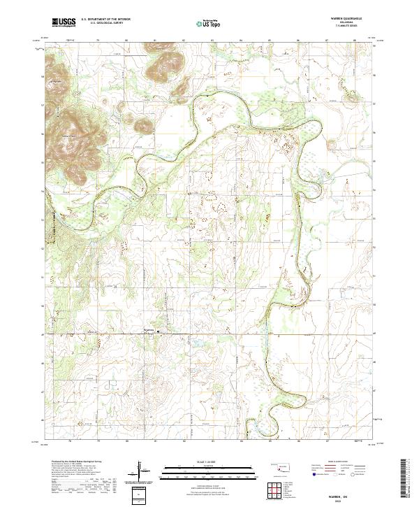
2022 Map of Warren
USGS Topo · Published 2022About this map
The settlement of Warren anchors this corner of Jackson County, situated along Warren Rd just south of the meandering North Fork Red River. The landscape is defined by the sharp transition from the river bottomlands to the dramatic elevations of the Wichita Mountains foothills in the northwest. Here, prominent peaks such as Flat Top Mtn and Soldiers Peak overlook the deep incision of Devils Canyon, providing a rugged contrast to the orderly grid of section roads like E1500 Rd that cross the plains to the east.
Find a feature on this map
35 named features on this map. Tap any name to fly to it.
Don’t see what you’re looking for? This feature index may not catch every label — zoom into the map to look around manually.
Map Details
Editions of this 2022 Warren Map
This is the sole edition of this map. No revisions or reprints were ever made.
Other maps of this area

1955 · Lawton
USGS Topo · 1:250,000

1963 · Babbs
USGS Topo · 1:24,000

1964 · Altus
USGS Topo · 1:24,000

1964 · Lone Wolf
USGS Topo · 1:24,000

1964 · Warren
USGS Topo · 1:24,000

1964 · Headrick
USGS Topo · 1:24,000
1964 · Roosevelt
USGS Topo · 1:24,000

1964 · Long Mountain
USGS Topo · 1:24,000

1971 · Blair
USGS Topo · 1:24,000

1971 · Lake Altus
USGS Topo · 1:24,000