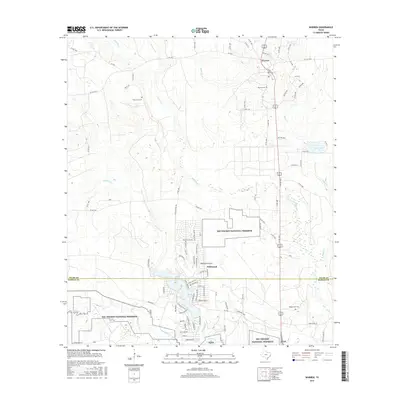
2016 Map of Warren
USGS Topo · Published 2016About this map
Big Thicket National Preserve land brackets the developing communities of Tyler County, showcasing a landscape defined by both conservation and settlement. The town of Warren sits in the northern portion of the map near Warren Cem, while the private community of Wildwood is centered around the Wildwood Airport further south. This 2016 survey illustrates the modern road network, including the interface between county roads and the Big Thicket parcels. Hydrological features such as Village Creek and Big Sandy Creek navigate the lower terrain, influencing the local layout. For genealogists, the map identifies several key burial sites, including Fellowship Cem and the Village Mills Cem near the southern border with Hardin County, providing essential locations for family history research in this East Texas timber region.
Find a feature on this map
92 named features on this map. Tap any name to fly to it.
Don’t see what you’re looking for? This feature index may not catch every label — zoom into the map to look around manually.
Map Details
Editions of this 2016 Warren Map
This is the sole edition of this map. No revisions or reprints were ever made.
Other maps of this area

1943 · Liberty
USGS Topo · 1:125,000

1954 · Beaumont
USGS Topo · 1:250,000

1955 · Saratoga
USGS Topo · 1:62,500

1955 · Kountze
USGS Topo · 1:62,500

1957 · Beaumont
USGS Topo · 1:250,000

1958 · Segno
USGS Topo · 1:62,500

1958 · Warren
USGS Topo · 1:62,500

1984 · Beaumont
USGS Topo · 1:250,000

1984 · Jacks Creek South
USGS Topo · 1:24,000

1984 · Jacks Creek North
USGS Topo · 1:24,000