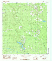
1984 Map of Warren
USGS Topo · Published 1985About this map
The Southern Pacific railroad corridor anchors this East Texas landscape, passing through the settlement of Warren and heading south toward the county line. The map captures a transition in land use during the mid-1980s, where traditional timber interests represented by the John H Kirby State Forest meet the conservation efforts of the Big Thicket National Preserve. To the south, the planned community of Wildwood surrounds the sprawling waters of Lake Kimball, contrasting with the more rural, creek-carved terrain to the north.
Find a feature on this map
17 named features on this map. Tap any name to fly to it.
Don’t see what you’re looking for? This feature index may not catch every label — zoom into the map to look around manually.
Map Details
Editions of this 1984 Warren Map
This is the sole edition of this map. No revisions or reprints were ever made.
Other maps of this area

1943 · Liberty
USGS Topo · 1:125,000

1954 · Beaumont
USGS Topo · 1:250,000

1955 · Saratoga
USGS Topo · 1:62,500

1955 · Kountze
USGS Topo · 1:62,500

1957 · Beaumont
USGS Topo · 1:250,000

1958 · Segno
USGS Topo · 1:62,500

1958 · Warren
USGS Topo · 1:62,500

1984 · Beaumont
USGS Topo · 1:250,000

1984 · Jacks Creek South
USGS Topo · 1:24,000

1984 · Jacks Creek North
USGS Topo · 1:24,000