
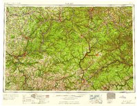
1959 Map of Warren
USGS Topo · Published 1959About this map
The Allegheny National Forest dominates this landscape of the late 1950s, preserving a massive tract of Northern Pennsylvania's highland wilderness during a peak era of industrial extraction. The map documents an extensive Oil Field spanning the western counties, highlighting the region's enduring legacy as the birthplace of the American petroleum industry. Along the Allegheny River, the Cornplanter (Indian Reservation) is clearly delineated near Warren, providing a significant historical marker of Indigenous presence before the construction of the Kinzua Dam.
Find a feature on this map
92 named features on this map. Tap any name to fly to it.
Don’t see what you’re looking for? This feature index may not catch every label — zoom into the map to look around manually.
Map Details
Editions of this 1959 Warren Map
2 editions found
Other maps of this area

1898 · Olean
USGS Topo · 1:62,500

1899 · Erie
USGS Topo · 1:62,500

1900 · Erie
USGS Topo · 1:62,500

1900 · Salamanca
USGS Topo · 1:62,500

1900 · Kittanning
USGS Topo · 1:62,500

1901 · Rural Valley
USGS Topo · 1:62,500

1902 · Kittanning
USGS Topo · 1:62,500

1903 · Curwensville
USGS Topo · 1:62,500

1903 · Rural Valley
USGS Topo · 1:62,500

1903 · Houtzdale
USGS Topo · 1:62,500