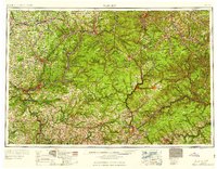
1959 Map of Warren
USGS Topo · Published 1959About this map
The Allegheny National Forest dominates this mid-century landscape, framing a region defined by its timber resources, early oil industry, and a complex network of river valleys and ridgelines. The map captures the territory before the completion of the Kinzua Dam, showing the Allegheny River winding through the Cornplanter Indian Reservation and the town of Warren. Further south, the industry of Oil City and Titusville is evident alongside extensive symbols for oil and gas wells.
Find a feature on this map
121 named features on this map. Tap any name to fly to it.
Don’t see what you’re looking for? This feature index may not catch every label — zoom into the map to look around manually.
Map Details
Editions of this 1959 Warren Map
2 editions found

Other maps of this area

1898 · Olean
USGS Topo · 1:62,500

1899 · Erie
USGS Topo · 1:62,500

1900 · Erie
USGS Topo · 1:62,500

1900 · Salamanca
USGS Topo · 1:62,500

1900 · Kittanning
USGS Topo · 1:62,500

1901 · Rural Valley
USGS Topo · 1:62,500

1902 · Kittanning
USGS Topo · 1:62,500

1903 · Curwensville
USGS Topo · 1:62,500

1903 · Rural Valley
USGS Topo · 1:62,500

1903 · Houtzdale
USGS Topo · 1:62,500