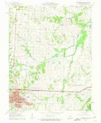
1962 Map of Warrensburg East
USGS Topo · Published 1963About this map
Central Missouri State College anchors the southwestern corner of this survey, marking a period of mid-century growth for the city of Warrensburg. The campus is surrounded by local institutions including Memorial Hospital and several neighborhood schools like Reese Sch and Southeast Sch. To the east, the landscape transitions into the rolling hills of Montserrat, where the Missouri Pacific railroad cuts through the terrain near several family burial grounds, including Maxwell Cem and Mayes Cem.
Find a feature on this map
54 named features on this map. Tap any name to fly to it.
Don’t see what you’re looking for? This feature index may not catch every label — zoom into the map to look around manually.
Map Details
Editions of this 1962 Warrensburg East Map
2 editions found
Other maps of this area

1885 · Warrensburg
USGS Topo · 1:125,000

1887 · Warrensburg
USGS Topo · 1:125,000

1894 · Warrensburg
USGS Topo · 1:125,000

1917 · Knobnoster
USGS Topo · 1:62,500

1947 · Jefferson City
USGS Topo · 1:250,000

1954 · Jefferson City
USGS Topo · 1:250,000

1954 · Centerview
USGS Topo · 1:24,000

1955 · Cornelia
USGS Topo · 1:24,000
1955 · Burtville
USGS Topo · 1:24,000

1955 · Jefferson City
USGS Topo · 1:250,000