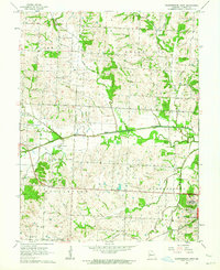
1962 Map of Warrensburg West
USGS Topo · Published 1964About this map
Blackwater River and its multiple tributaries, including the North Fork and South Fork, define the central geography of this West-Central Missouri landscape during the early 1960s. The settlement of Centerview serves as a local hub along the Missouri Pacific railroad line, while the western edge of Warrensburg begins to encroach on the eastern margin of the sheet. Rural life is anchored by several small burial grounds such as Mount Maria Cem and Dixon Cem, along with Jacoby Chapel. The emergence of modern infrastructure is evident through the inclusion of Sky Haven Airport and a municipal Sewage Disposal plant. The terrain transitions from the well-watered valleys of Honey Creek and Walnut Creek to the higher elevations of the surrounding townships, showing the established agricultural grid and road network before significant suburban expansion.
Find a feature on this map
23 named features on this map. Tap any name to fly to it.
Don’t see what you’re looking for? This feature index may not catch every label — zoom into the map to look around manually.
Map Details
Editions of this 1962 Warrensburg West Map
2 editions found
Other maps of this area

1885 · Warrensburg
USGS Topo · 1:125,000

1887 · Warrensburg
USGS Topo · 1:125,000

1894 · Warrensburg
USGS Topo · 1:125,000

1917 · Knobnoster
USGS Topo · 1:62,500

1947 · Jefferson City
USGS Topo · 1:250,000

1954 · Jefferson City
USGS Topo · 1:250,000

1954 · Centerview
USGS Topo · 1:24,000
1954 · Holden
USGS Topo · 1:24,000

1955 · Cornelia
USGS Topo · 1:24,000

1955 · Jefferson City
USGS Topo · 1:250,000