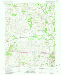
1962 Map of Warrensburg West
USGS Topo · Published 1982About this map
The Blackwater River snakes horizontally across this landscape, dividing the northern uplands of Columbus and Hazel Hill townships from the southern plains. The Missouri Pacific railroad corridor anchors the southern portion of the map, passing through the settlement of Centerview and the western edge of Warrensburg. This 1962 topography, updated with 1980 photogrammetric revisions, provides a clear record of rural Johnson County before modern expansion. Genealogists will find several burial grounds, including the large Sunset Hill Cemetery and smaller family sites like Houx Cem and Dixon Cem. Local infrastructure is marked by Sky Haven Airport and the Sewage Disposal plant near the city limits. The terrain is defined by a dense network of tributaries like Honey Creek, Walnut Creek, and Post Oak Branch, which feed into the river system, shaping the agricultural patterns of the early 1960s.
Find a feature on this map
28 named features on this map. Tap any name to fly to it.
Don’t see what you’re looking for? This feature index may not catch every label — zoom into the map to look around manually.
Map Details
Editions of this 1962 Warrensburg West Map
2 editions found
Other maps of this area

1885 · Warrensburg
USGS Topo · 1:125,000

1887 · Warrensburg
USGS Topo · 1:125,000

1894 · Warrensburg
USGS Topo · 1:125,000

1917 · Knobnoster
USGS Topo · 1:62,500

1947 · Jefferson City
USGS Topo · 1:250,000

1954 · Jefferson City
USGS Topo · 1:250,000

1954 · Centerview
USGS Topo · 1:24,000
1954 · Holden
USGS Topo · 1:24,000

1955 · Cornelia
USGS Topo · 1:24,000

1955 · Jefferson City
USGS Topo · 1:250,000