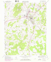
1966 Map of Warrenton
USGS Topo · Published 1978About this map
Warrenton serves as the focal point of this Northern Virginia landscape, which transitioned during the mid-20th century from a rural county seat into a regional hub. The town is surrounded by a mix of educational and civic institutions, including Taylor High Sch and Fauquier Hospital. To the west, the Warrenton Training Center occupies significant acreage near Vientree Mtn, while the southern reaches are marked by the historic grounds of Fauquier White Sulphur Springs near the Rappahannock River. The mapping captures the expansion of infrastructure, such as the Southern railroad line passing through Meetze and the development of the Warrenton Air Park. Conservation and recreation are represented by the Whitney State Forest, providing a counterpoint to the growing residential areas like Frytown and Fletcherville.
Find a feature on this map
48 named features on this map. Tap any name to fly to it.
Don’t see what you’re looking for? This feature index may not catch every label — zoom into the map to look around manually.
Map Details
Editions of this 1966 Warrenton Map
4 editions found
Other maps of this area

1894 · Warrenton
USGS Topo · 1:125,000

1894 · Warrenton
USGS Topo · 1:62,500

1927 · Remington
USGS Topo · 1:48,000

1930 · Warrenton
USGS Topo · 1:62,500

1933 · Middleburg
USGS Topo · 1:62,500

1943 · Catlett
USGS Topo · 1:62,500

1943 · Thorofare Gap
USGS Topo · 1:24,000

1943 · Orlean
USGS Topo · 1:24,000

1943 · Midland
USGS Topo · 1:24,000

1943 · Marshall
USGS Topo · 1:24,000