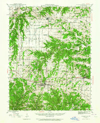
1943 Map of Warrenton
USGS Topo · Published 1964About this map
The county seat of Warrenton and the adjacent town of Truesdale anchor this mid-century portrait of Warren and Lincoln Counties. The landscape is defined by the east-west corridor of the Wabash railroad, which connects the main settlements of Wright City and Warrenton, while the north is served by the Chicago Burlington And Quincy line near Hawk Point. This era shows a dense network of rural infrastructure, where nearly every township—from Elkhorn to Hickory—retains its own neighborhood anchor like Lippstadt Sch, Jones Sch, or Pleasant Hill Sch.
Find a feature on this map
62 named features on this map. Tap any name to fly to it.
Don’t see what you’re looking for? This feature index may not catch every label — zoom into the map to look around manually.
Map Details
Editions of this 1943 Warrenton Map
2 editions found

Other maps of this area

1890 · Louisiana
USGS Topo · 1:125,000

1890 · Hermann
USGS Topo · 1:125,000

1903 · O'Fallon
USGS Topo · 1:125,000

1934 · Elsberry
USGS Topo · 1:48,000

1936 · Hermann
USGS Topo · 1:48,000

1937 · Silex
USGS Topo · 1:62,500

1939 · Silex
USGS Topo · 1:48,000

1941 · Troy
USGS Topo · 1:62,500

1942 · Elsberry
USGS Topo · 1:62,500

1942 · Hermann
USGS Topo · 1:62,500