
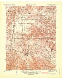
1945 Map of Warrenton
USGS Topo · Published 1945About this map
The county seat of Warrenton serves as the central hub for this mid-century Missouri landscape, where the Wabash railroad corridor facilitates movement through the central Elkhorn and Camp Branch townships. This 1940s-era study captures the transition from a railroad-dependent economy to the beginnings of modern highway development, with an Airway Beacon situated in the western hills indicating early aviation infrastructure. The map is densely populated with community landmarks, including numerous small country schools like Dime Run Sch and Pleasant Hill Sch, and legacy burial grounds such as Camp Branch Cem and Slavens Cem. To the north, the Chicago and Burlington rail line anchors the settlement of Hawk Point, while the southern reaches descend toward Charrette Creek and the wooded terrain around Roundabout Hill.
Find a feature on this map
76 named features on this map. Tap any name to fly to it.
Don’t see what you’re looking for? This feature index may not catch every label — zoom into the map to look around manually.
Map Details
Editions of this 1945 Warrenton Map
2 editions found
Other maps of this area

1890 · Louisiana
USGS Topo · 1:125,000

1890 · Hermann
USGS Topo · 1:125,000

1903 · O'Fallon
USGS Topo · 1:125,000

1934 · Elsberry
USGS Topo · 1:48,000

1936 · Hermann
USGS Topo · 1:48,000

1937 · Silex
USGS Topo · 1:62,500

1939 · Silex
USGS Topo · 1:48,000

1941 · Troy
USGS Topo · 1:62,500

1942 · Elsberry
USGS Topo · 1:62,500

1942 · Hermann
USGS Topo · 1:62,500