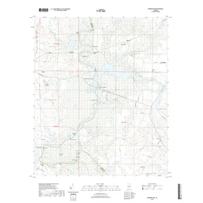
2018 Map of Warrior Dam
USGS Topo · Published 2018About this map
The Black Warrior River carves a complex course through the western Alabama landscape on the border of Greene and Hale Counties. This riverine environment is defined by its numerous named bars, bluffs, and shoals, such as Lumbus Bar, Browns Bluff, and Big Creek Shoals. The dominant infrastructure is the Warrior Dam, which regulates the flow of the river into Warrior Lake. The city of Eutaw sits on the western edge of the quadrangle, serving as a primary settlement node alongside smaller communities like Gosa and McClure. The interior landscape reveals a history of river crossings and local navigation, evidenced by features like the Oscar Underwood Bridge and the point at Jennings Ferry Point. Numerous cemeteries including New Christian Cem and Jackson Chapel Cem are distributed throughout the rural landscape, providing essential data points for local genealogy and history.
Find a feature on this map
80 named features on this map. Tap any name to fly to it.
Don’t see what you’re looking for? This feature index may not catch every label — zoom into the map to look around manually.
Map Details
Editions of this 2018 Warrior Dam Map
This is the sole edition of this map. No revisions or reprints were ever made.
Other maps of this area

1927 · Eutaw
USGS Topo · 1:48,000

1931 · Eutaw
USGS Topo · 1:62,500

1947 · Mason Bend
USGS Topo · 1:24,000

1947 · Forkland
USGS Topo · 1:24,000

1948 · Mason Bend
USGS Topo · 1:24,000

1949 · Forkland
USGS Topo · 1:24,000

1953 · Montgomery
USGS Topo · 1:250,000

1956 · Montgomery
USGS Topo · 1:250,000

1957 · Montgomery
USGS Topo · 1:250,000
1980 · Union
USGS Topo · 1:24,000