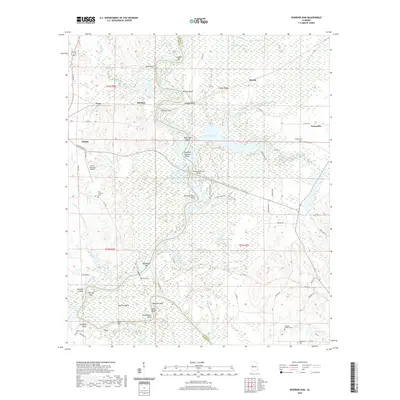
2020 Map of Warrior Dam
USGS Topo · Published 2020About this map
The Warrior Dam and the expansive waters of Warrior Lake dominate this Greene County landscape, illustrating the controlled flow of the Black Warrior River as it snakes between Greene Co and Hale Co. The terrain is a complex network of wetlands and riverine features, including the Cypress Swamp, Dollashide Swamp, and numerous named bars and shoals such as Milkhouse Bar and Halls Shoals. This area reflects a long history of river navigation and rural settlement, with the town of Eutaw positioned near the Eutaw Municipal Airport and the historic crossing at Jennings Ferry Point.
Find a feature on this map
77 named features on this map. Tap any name to fly to it.
Don’t see what you’re looking for? This feature index may not catch every label — zoom into the map to look around manually.
Map Details
Editions of this 2020 Warrior Dam Map
This is the sole edition of this map. No revisions or reprints were ever made.
Other maps of this area

1927 · Eutaw
USGS Topo · 1:48,000

1931 · Eutaw
USGS Topo · 1:62,500

1947 · Mason Bend
USGS Topo · 1:24,000

1947 · Forkland
USGS Topo · 1:24,000

1948 · Mason Bend
USGS Topo · 1:24,000

1949 · Forkland
USGS Topo · 1:24,000

1953 · Montgomery
USGS Topo · 1:250,000

1956 · Montgomery
USGS Topo · 1:250,000

1957 · Montgomery
USGS Topo · 1:250,000
1980 · Union
USGS Topo · 1:24,000