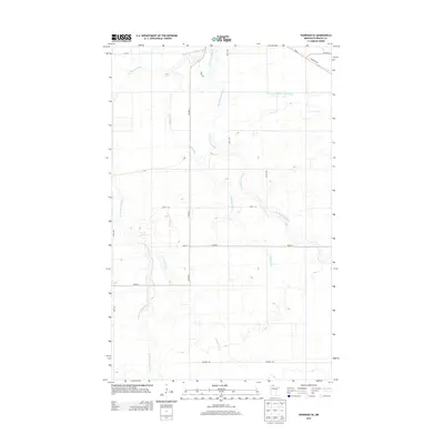
2013 Map of Warroad SE
USGS Topo · Published 2013About this map
The W Br Warroad River and E Br Warroad River define the drainage patterns of this Roseau County landscape, converging in a complex network of wetlands and small tributaries. This northern Minnesota terrain is further shaped by Bulldog Run and the seasonal flows of Clausner Cr, which navigate the low-lying topography. The map illustrates a developed rural grid characterized by long straightaways like 600TH Ave and established routes such as MN-11 and Co Hwy-2. The heavy reliance on water management is evident in the presence of County Ditch Number Twentyfive, a significant engineering feature common in this region to support agricultural and forest land use. Local landmarks include Tangnes Trl and Kirkwood Dr, which anchor the smaller access points within the larger township sections.
Find a feature on this map
17 named features on this map. Tap any name to fly to it.
Don’t see what you’re looking for? This feature index may not catch every label — zoom into the map to look around manually.
Map Details
Editions of this 2013 Warroad SE Map
This is the sole edition of this map. No revisions or reprints were ever made.
Other maps of this area

1918 · Winterroad
USGS Topo · 1:62,500

1918 · Roosevelt
USGS Topo · 1:62,500

1918 · Warroad
USGS Topo · 1:62,500

1943 · Roosevelt
USGS Topo · 1:62,500

1943 · Warroad
USGS Topo · 1:62,500

1954 · Roseau
USGS Topo · 1:250,000

1957 · Roseau
USGS Topo · 1:250,000

1958 · Roseau
USGS Topo · 1:250,000

1967 · Roosevelt NW
USGS Topo · 1:24,000
1967 · Warroad SE
USGS Topo · 1:24,000