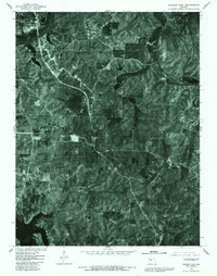
1980 Map of Warsaw East
USGS Topo · Published 1982About this map
Warsaw and its surrounding river valleys are captured here just as the landscape underwent a massive transformation with the development of the Harry S Truman Reservoir. This 1980 orthophotoquad combines aerial photography with topographic precision, showing the intricate finger-like extensions of the Lake of the Ozarks as they push into the surrounding hills. The imagery provides a clear look at the Osage River corridor before the full impact of new water levels fully altered the local geography. Small settlements and rural junctions like Whitakerville, Dell Junction, and Dell are visible alongside the wooded drainages of Turkey Creek. This specific edition is particularly valuable for researchers looking to identify property lines, road networks, and original structures at the very moment the modern lake system was being finalized, preserving a visual record of the older valley floor topography alongside the newer shoreline developments at White Branch and Blue Branch.
Find a feature on this map
11 named features on this map. Tap any name to fly to it.
Don’t see what you’re looking for? This feature index may not catch every label — zoom into the map to look around manually.
Map Details
Editions of this 1980 Warsaw East Map
This is the sole edition of this map. No revisions or reprints were ever made.
Other maps of this area

1887 · Warsaw
USGS Topo · 1:125,000

1894 · Warsaw
USGS Topo · 1:125,000

1935 · Edwards
USGS Topo · 1:24,000

1935 · Dell
USGS Topo · 1:24,000

1936 · Shawnee Bend
USGS Topo · 1:24,000

1936 · Lakeview Heights
USGS Topo · 1:24,000

1936 · Schuyler
USGS Topo · 1:24,000

1945 · Fristoe
USGS Topo · 1:62,500

1947 · Jefferson City
USGS Topo · 1:250,000

1954 · Jefferson City
USGS Topo · 1:250,000