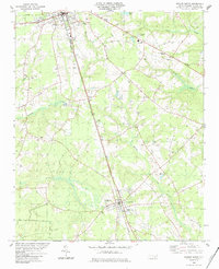
1984 Map of Warsaw South
USGS Topo · Published 1984About this map
Warsaw and Magnolia anchor this 1980s landscape, positioned along the busy corridor of the Seaboard railroad. The region is characterized by a high concentration of community centers and local burial grounds, including the Rose Hill Cem and Pine Crest Cem. Educational facilities such as James Kenan High Sch and Douglas Jr High Sch serve the rural population, while several churches like St Peter Ch and Hines Chapel dot the crossroads. The terrain is defined by a web of drainage including Stewarts Creek, Maxwell Creek, and Millers Creek, with local industry represented by a Sandpit and the aviation hub at Taylor Field. This survey captures the Duplin County interior during a period of established agricultural and infrastructure growth.
Find a feature on this map
33 named features on this map. Tap any name to fly to it.
Don’t see what you’re looking for? This feature index may not catch every label — zoom into the map to look around manually.
Map Details
Editions of this 1984 Warsaw South Map
This is the sole edition of this map. No revisions or reprints were ever made.
Other maps of this area

1943 · Kenansville
USGS Topo · 1:62,500

1948 · Kenansville
USGS Topo · 1:62,500

1953 · Florence
USGS Topo · 1:250,000

1953 · Rocky Mount
USGS Topo · 1:250,000

1953 · Raleigh
USGS Topo · 1:250,000

1953 · Beaufort
USGS Topo · 1:250,000

1954 · Rocky Mount
USGS Topo · 1:250,000

1954 · Florence
USGS Topo · 1:250,000

1954 · Raleigh
USGS Topo · 1:250,000

1954 · Beaufort
USGS Topo · 1:250,000