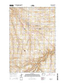
2014 Map of Wasco
USGS Topo · Published 2014About this map
Wasco serves as the primary hub of this high plateau region in Sherman County, where the convergence of Us-97 and Or-206 underscores the town's historical and modern role as a transit point. The landscape is deeply incised by a network of drainage features like Spanish Hollow and China Hollow Cr, revealing the complex topography of the Columbia Plateau. To the south, the smaller settlement of De Moss Springs sits near the head of De Moss Canyon, while Wasco State Airport occupies the level ground east of the city. Genealogists will find notable burial sites including Sunrise Cem and the Wasco Methodist Cem, as well as the De Moss Cem further south. The map documents numerous local family names preserved in the road network, such as Van Gilder Rd and Hilderbrand Ln, which connect the scattered agricultural tracts across Gordon Ridge.
Find a feature on this map
48 named features on this map. Tap any name to fly to it.
Don’t see what you’re looking for? This feature index may not catch every label — zoom into the map to look around manually.
Map Details
Editions of this 2014 Wasco Map
This is the sole edition of this map. No revisions or reprints were ever made.
Other maps of this area

1953 · The Dalles
USGS Topo · 1:250,000

1956 · The Dalles
USGS Topo · 1:250,000

1957 · The Dalles
USGS Topo · 1:250,000

1957 · Wasco
USGS Topo · 1:62,500

1957 · Wishram
USGS Topo · 1:62,500

1962 · Erskine
USGS Topo · 1:24,000

1971 · Moro
USGS Topo · 1:24,000

1971 · Quinton
USGS Topo · 1:24,000
1971 · Klondike
USGS Topo · 1:24,000
1971 · Harmony
USGS Topo · 1:24,000