
1957 Map of Wasco
USGS Topo · Published 1959About this map
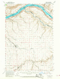
Columbia River rapids and steep canyon walls define this stretch of the Pacific Northwest, where the Union Pacific and the Spokane Portland and Seattle RR trace opposite banks of the water. The landscape is marked by a series of turbulent water features, including Indian Rapids, Hook Rapids, and the multi-staged Lower John Day Rapids at the river's confluence. Inland, the plateau is deeply carved by drainage systems such as Spanish Hollow and China Hollow, which lead toward the hub of Wasco.
Find a feature on this map
58 named features on this map. Tap any name to fly to it.
Don’t see what you’re looking for? This feature index may not catch every label — zoom into the map to look around manually.
Map Details
Editions of this 1957 Wasco Map
2 editions found
Other maps of this area

1916 · Arlington
USGS Topo · 1:125,000

1916 · Condon
USGS Topo · 1:125,000

1953 · The Dalles
USGS Topo · 1:250,000

1956 · The Dalles
USGS Topo · 1:250,000

1957 · The Dalles
USGS Topo · 1:250,000

1957 · Goldendale
USGS Topo · 1:62,500

1957 · Wishram
USGS Topo · 1:62,500

1957 · Satus Pass
USGS Topo · 1:62,500

1962 · Erskine
USGS Topo · 1:24,000

1964 · Mc Donald
USGS Topo · 1:24,000