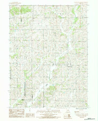
1984 Map of Washington Center
USGS Topo · Published 1985About this map
Washington Center serves as the central focal point of this Harrison County landscape during the early 1980s, situated amidst a complex network of tributaries. The topography is defined by the drainage systems of Big Rock Creek and Little Rock Creek to the west, while the eastern portion is dominated by the West Fork and East Fork. A significant portion of the southwestern terrain is occupied by the Emmett and Leah Seat Memorial Wildlife Area, which spans across the borders of Worth and Gentry counties. The map provides a detailed view of the rural township structure, showing the intersecting boundaries of Smith, Lincoln, Allen, and Washington. This era of the landscape is characterized by a high density of small watercourses, including Little Muddy Creek, Muddy Creek, and Big Muddy Creek, illustrating the intricate natural irrigation that has long influenced agricultural patterns in this part of Missouri.
Find a feature on this map
19 named features on this map. Tap any name to fly to it.
Don’t see what you’re looking for? This feature index may not catch every label — zoom into the map to look around manually.
Map Details
Editions of this 1984 Washington Center Map
This is the sole edition of this map. No revisions or reprints were ever made.
Other maps of this area

1940 · Blockton
USGS Topo · 1:62,500

1942 · Grant City
USGS Topo · 1:62,500

1943 · Grant City
USGS Topo · 1:62,500

1943 · Blockton
USGS Topo · 1:62,500

1945 · Mount Ayr
USGS Topo · 1:62,500

1947 · Mount Ayr
USGS Topo · 1:62,500

1948 · Bethany
USGS Topo · 1:62,500

1955 · Nebraska City
USGS Topo · 1:250,000

1957 · Nebraska City
USGS Topo · 1:250,000

1958 · Nebraska City
USGS Topo · 1:250,000