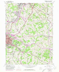
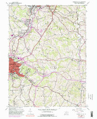
1953 Map of Washington East
USGS Topo · Published 1981About this map
The industrial and academic landscape of Washington is captured during a period of significant mid-century transition. The city is anchored by the historic campus of Washington and Jefferson College, while the surrounding terrain reflects a deep-rooted reliance on resource extraction, evidenced by a prominent Stone Quarry and multiple strip mining operations near Houston and McGovern. The infrastructure of the era is defined by the heavy rail lines of the Baltimore and Ohio Railroad and Penn Central, which weave through valleys shaped by Chartiers Creek and Catfish Creek. Genealogists will find a wealth of localized data across the townships of North Strabane and South Strabane, from the Hillsview Sanatorium and Judge Chambers landmark to numerous community focal points like the Hill Church and St Johns Cem.
Find a feature on this map
71 named features on this map. Tap any name to fly to it.
Don’t see what you’re looking for? This feature index may not catch every label — zoom into the map to look around manually.
Map Details
Editions of this 1953 Washington East Map
5 editions found
Other maps of this area

1901 · Amity
USGS Topo · 1:62,500

1904 · Amity
USGS Topo · 1:62,500

1904 · Carnegie
USGS Topo · 1:62,500

1904 · Burgettstown
USGS Topo · 1:62,500

1906 · Burgettstown
USGS Topo · 1:62,500

1906 · Carnegie
USGS Topo · 1:62,500

1907 · Claysville
USGS Topo · 1:62,500

1908 · Carnegie
USGS Topo · 1:62,500

1951 · Canton
USGS Topo · 1:250,000

1953 · Canton
USGS Topo · 1:250,000
Featured Places
- Washington, PA
- South Strabane Township, PA
- Mount Pleasant, South Strabane Township
- McGovern, Chartiers Township
- East Washington, PA