
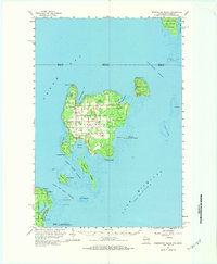
1960 Map of Washington Island
USGS Topo · Published 1962About this map
Washington Island stands as the central anchor of this Door County maritime landscape, connected by ferry across the treacherous Porte Des Morts Passage. The 1960 field check captures a community defined by its natural harbors, such as Detroit Harbor and Jackson Harbor, and a scattering of inland Gravel Pits reflecting local infrastructure. Notable landmarks like the Pottawatomie Light on Rock Island and the Washington Island Landing Field highlight the island's role as a navigational hub at the mouth of Green Bay. Significant natural preserves including the Green Bay National Wildlife Refuge and Coffer Swamp illustrate the varied terrain of the archipelago. For local historians, the inclusion of Trinity Ch and the remote St Martin Cem on St Martin Island provides vital data on early settlements and community life across the scattered islands of the Rock Island Passage.
Find a feature on this map
49 named features on this map. Tap any name to fly to it.
Don’t see what you’re looking for? This feature index may not catch every label — zoom into the map to look around manually.
Map Details
Editions of this 1960 Washington Island Map
2 editions found
Other maps of this area

1932 · Burnt Bluff SW
USGS Topo · 1:31,680

1954 · Escanaba
USGS Topo · 1:250,000

1957 · Escanaba
USGS Topo · 1:250,000

1958 · Escanaba
USGS Topo · 1:250,000

1958 · Escanaba
USGS Topo · 1:62,500

1958 · Peninsula Point
USGS Topo · 1:62,500

1958 · Fairport
USGS Topo · 1:62,500

1960 · Sister Bay
USGS Topo · 1:62,500

1960 · Ellison Bay
USGS Topo · 1:62,500

1981 · Marinette
USGS Topo · 1:100,000