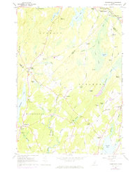
1961 Map of Washington
USGS Topo · Published 1974About this map
Appleton Ridge dominates the eastern landscape of this survey, dividing the drainage between the St George River and Pettengill Stream. The rural network of the early 1960s is defined by numerous crossroads settlements such as Burkettville, West Appleton, and South Liberty, reflecting a localized economy tied to the land. This era captures the transition of the Maine interior, where family heritage is anchored by dispersed burial grounds like Hannon Cem and Miller Cem.
Find a feature on this map
70 named features on this map. Tap any name to fly to it.
Don’t see what you’re looking for? This feature index may not catch every label — zoom into the map to look around manually.
Map Details
Editions of this 1961 Washington Map
3 editions found
Other maps of this area

1904 · Rockland
USGS Topo · 1:62,500

1906 · Rockland
USGS Topo · 1:62,500

1913 · Waldoboro
USGS Topo · 1:48,000

1915 · Waldoboro
USGS Topo · 1:62,500

1915 · Belfast
USGS Topo · 1:62,500

1916 · Liberty
USGS Topo · 1:62,500

1917 · Belfast
USGS Topo · 1:62,500

1941 · Belfast
USGS Topo · 1:62,500

1941 · Rockland
USGS Topo · 1:62,500

1941 · Waldoboro
USGS Topo · 1:62,500