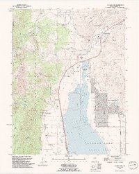
1994 Map of Washoe City
USGS Topo · Published 1994About this map
Washoe Lake and Little Washoe Lake dominate the central basin of this valley, flanked by the steep slopes of the Carson National Forest to the west. This 1990s revision reveals a landscape where historical industrial footprints meet modern residential expansion. The presence of the Ophir Mill Hist Marker and the Union Mine near Pleasant Valley points to the area's silver-era heritage, while the developing grid of New Washoe City reflects later growth. In the southwest, the venerable Franktown settlement remains near Bowers Mansion County Park, a site tied to the Comstock Lode's earliest wealth. Genealogists can locate several burial grounds including Whispering Pines Cem, Hot Springs Cem, and Franktown Cem, all situated along the valley's western edge where Ophir Creek and Galena Creek descend from the mountains.
Find a feature on this map
59 named features on this map. Tap any name to fly to it.
Don’t see what you’re looking for? This feature index may not catch every label — zoom into the map to look around manually.
Map Details
Editions of this 1994 Washoe City Map
2 editions found
Other maps of this area

1891 · Carson
USGS Topo · 1:125,000

1893 · Carson
USGS Topo · 1:125,000

1950 · Virginia City
USGS Topo · 1:62,500

1950 · Mt. Rose
USGS Topo · 1:62,500

1952 · Mt. Rose
USGS Topo · 1:62,500

1952 · Virginia City
USGS Topo · 1:62,500

1955 · Marlette Lake
USGS Topo · 1:24,000

1956 · Dayton
USGS Topo · 1:62,500

1956 · Carson City
USGS Topo · 1:62,500

1957 · Reno
USGS Topo · 1:250,000