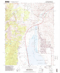
1994 Map of Washoe City
USGS Topo · Published 1994About this map
Washoe Lake and its surrounding valley floor anchor this 1994 revision, illustrating the shift from early industrial milling to modern residential and recreational land use. The map documents the spatial relationship between the established settlement of Franktown and the burgeoning New Washoe City, with its grid of suburban streets like Chipmunk Drive and Esmeralda Dr.
Find a feature on this map
62 named features on this map. Tap any name to fly to it.
Don’t see what you’re looking for? This feature index may not catch every label — zoom into the map to look around manually.
Map Details
Editions of this 1994 Washoe City Map
2 editions found
Other maps of this area

1891 · Carson
USGS Topo · 1:125,000

1893 · Carson
USGS Topo · 1:125,000

1950 · Virginia City
USGS Topo · 1:62,500

1950 · Mt. Rose
USGS Topo · 1:62,500

1952 · Mt. Rose
USGS Topo · 1:62,500

1952 · Virginia City
USGS Topo · 1:62,500

1955 · Marlette Lake
USGS Topo · 1:24,000

1956 · Dayton
USGS Topo · 1:62,500

1956 · Carson City
USGS Topo · 1:62,500

1957 · Reno
USGS Topo · 1:250,000