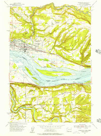
1954 Map of Washougal
USGS Topo · Published 1957About this map
The Columbia River serves as the dividing line between Washington and Oregon in this mid-century survey, with the industrial and residential development of Washougal and Camas anchoring the northern bank. Along the river, substantial terrain features like Reed Island, Gary Island, and Flag Island dominate the waterway, while the Spokane Portland and Seattle Railway and Columbia River Highway follow the banks, illustrating the importance of this transport corridor.
Find a feature on this map
61 named features on this map. Tap any name to fly to it.
Don’t see what you’re looking for? This feature index may not catch every label — zoom into the map to look around manually.
Map Details
Editions of this 1954 Washougal Map
This is the sole edition of this map. No revisions or reprints were ever made.
Other maps of this area

1911 · Boring
USGS Topo · 1:48,000

1914 · Boring
USGS Topo · 1:62,500

1916 · Estacada
USGS Topo · 1:125,000

1918 · Troutdale
USGS Topo · 1:62,500

1934 · Troutdale
USGS Topo · 1:48,000

1940 · Boring
USGS Topo · 1:62,500

1941 · Camas
USGS Topo · 1:62,500

1942 · Camas
USGS Topo · 1:62,500

1948 · Vancouver
USGS Topo · 1:250,000

1950 · Vancouver
USGS Topo · 1:250,000