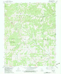
1982 Map of Wasola
USGS Topo · Published 1983About this map
Wasola serves as a central point in this rugged portion of the Ozarks, situated along the border of Douglas and Ozark counties. The landscape is defined by deep hollows and high ridges, including Ridge and Backbone, with numerous springs and fords punctuating the drainage basins of Barren Fork and Little Creek. The area within the Mark Twain National Forest shows a scattered network of rural life, anchored by small community centers like Squires, Girdner, and Almartha. Genealogists will find a wealth of local history in the distribution of family-named landmarks and country churches, such as Murray Ch and Oak Grove Ch, alongside several isolated burial grounds including Hilo Cem and Herndon Cem. The presence of several fords across Little Prong and Teeter Creek highlights the historic reliance on seasonal water crossings before modern infrastructure dominated these hills.
Find a feature on this map
38 named features on this map. Tap any name to fly to it.
Don’t see what you’re looking for? This feature index may not catch every label — zoom into the map to look around manually.
Map Details
Editions of this 1982 Wasola Map
This is the sole edition of this map. No revisions or reprints were ever made.
Other maps of this area

1934 · Gainesville
USGS Topo · 1:48,000

1936 · Thornfield
USGS Topo · 1:48,000

1936 · Ava
USGS Topo · 1:48,000

1937 · Buckhart
USGS Topo · 1:48,000

1940 · Gainesville
USGS Topo · 1:62,500

1942 · Ava
USGS Topo · 1:62,500

1943 · Thornfield
USGS Topo · 1:62,500

1943 · Buckhart
USGS Topo · 1:62,500

1945 · Ava
USGS Topo · 1:62,500

1945 · Harrison
USGS Topo · 1:250,000