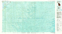
1980 Map of Wassaw Sound
USGS Topo · Published 1983About this map
Wilmington Island and the neighboring community of Wilmington Park anchor the northwestern corner of this coastal study, marking the transition from residential development to the complex estuarine environments of the Georgia coast. The map emphasizes the intricate network of tidal waterways, including the Wilmington River, Bull River, and Wassaw Creek, which weave through Romerly Marsh Creek and around numerous barrier islands. This 1980 edition provides a high-resolution view of the bathymetry within the Wassaw Sound, documenting the shifting underwater topography and sandbars near Wassaw National Wildlife Refuge. Significant protected areas are clearly delineated, from the coastal defenses of Fort Pulaski National Monument in the north to the uninhabited reaches of Little Tybee Island and Williamson Island. The mapping of features like Cape Charlotte and Cape May alongside depth contours illustrates the ongoing interaction between the Atlantic Ocean and the fragile marshes of Chatham County.
Find a feature on this map
21 named features on this map. Tap any name to fly to it.
Don’t see what you’re looking for? This feature index may not catch every label — zoom into the map to look around manually.
Map Details
Editions of this 1980 Wassaw Sound Map
2 editions found
Other maps of this area

1920 · Wassaw Sound
USGS Topo · 1:62,500

1920 · Cabretta Island
USGS Topo · 1:62,500

1920 · Hilton Head
USGS Topo · 1:62,500

1920 · Bluffton
USGS Topo · 1:62,500

1928 · St Catherines Island
USGS Topo · 1:62,500

1942 · Savannah
USGS Topo · 1:62,500

1943 · St Catherines Island
USGS Topo · 1:62,500

1944 · Cabretta Island
USGS Topo · 1:62,500

1944 · Ossabaw Island
USGS Topo · 1:62,500

1945 · St. Catherine's Island
USGS Topo · 1:62,500