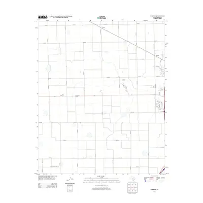
2012 Map of Wasson
USGS Topo · Published 2012About this map
Agricultural infrastructure and small rural settlements dominate this High Plains landscape in the early 21st century. The map centers on the intensive farming operations between the communities of Boone and Wasson, where the grid-based road system supports a local economy tied to cotton production. Industrial landmarks such as the Heck Cotton Gin and the West Side Cotton Gin indicate the processing hubs for the surrounding fields. The natural drainage of Slaton Draw cuts through the otherwise geometric regularity of the terrain, providing a rare topographical break in the vast expanse of Texas cropland. Local aviation is represented by the Quarterway Airport, while a network of county roads, including Co RD-50 and Co RD-120, provides essential connectivity for these remote agricultural outposts.
Find a feature on this map
40 named features on this map. Tap any name to fly to it.
Don’t see what you’re looking for? This feature index may not catch every label — zoom into the map to look around manually.
Map Details
Editions of this 2012 Wasson Map
This is the sole edition of this map. No revisions or reprints were ever made.
Other maps of this area

1954 · Plainview
USGS Topo · 1:250,000

1958 · Plainview
USGS Topo · 1:250,000

1965 · Kress West
USGS Topo · 1:24,000

1965 · Edmonson
USGS Topo · 1:24,000

1965 · Wasson
USGS Topo · 1:24,000

1965 · Plainview
USGS Topo · 1:24,000

1968 · Halfway
USGS Topo · 1:24,000

1968 · Happy Union
USGS Topo · 1:24,000
1968 · Hale Center SW
USGS Topo · 1:24,000
1968 · Hale Center
USGS Topo · 1:24,000